Size
≈ 4,900 acres
On the city's southeast side sits roughly 4,900 acres of former coal mine — rolling Blackland Prairie hills, a chain of lakes, and the largest economic development opportunity in our city's history. It's also the subject of more confusion than anything else in local government right now. This page separates the pieces.
For decades, the Thermo site was a lignite coal mine serving northeast Texas' power industry — most recently under Luminant. Mining ended, the land was reclaimed, and the site is now under City ownership and entirely inside the city limits — annexed into Sulphur Springs in March 2020: approximately 4,900 acres on the city's southeast side, with large continuous developable areas, convenient utility access, and a unique system of lakes, streams, and wetlands left behind by the mining era.
That combination — big open parcels plus utility access — is why the site has drawn substantial interest from emerging industries, most notably data centers. And it's why the Sulphur Springs Economic Development Corporation (SSEDC) commissioned a professional master plan for the site — so the community can see and weigh a whole-site vision before development hardens into place.
The Matrix Reserve Master Plan — commissioned by the SSEDC and prepared by Toole Design in June 2025 — sets out a long-term vision for the whole site: not just where industry goes, but what gets conserved, where parks and trails run, and how the site connects back to Sulphur Springs. The plan is organized around four "big moves":
The master plan is a proposed concept, not adopted city policy. It was commissioned by the SSEDC; it has not been presented to the City Council in an open meeting, and the council has not voted to adopt it. Nothing in it binds anyone yet. Any part of it that moves forward — zoning, standards, land transactions, public improvements — happens through the public council processes described in How Cities Are Governed.
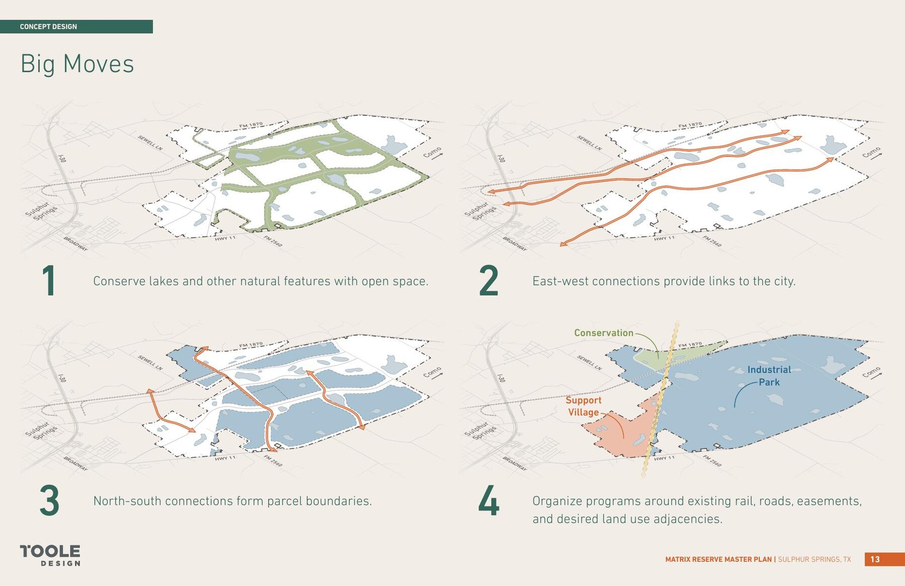
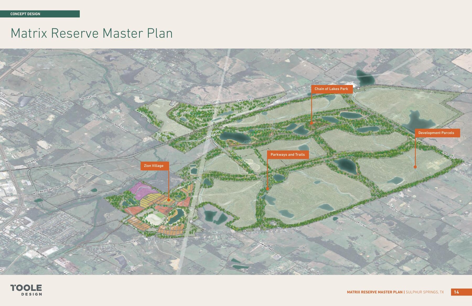
Over 2,000 acres of development parcels for emerging high-tech industry — such as data centers and other light industrial uses — subdivided and buffered so parkways, trails, and green corridors run between the development parcels.
A park system surrounding the site's existing lakes with new green spaces, active recreation areas, and pavilions, tied together by a trail network — shared-use paths, natural-surface trails, and dedicated equestrian trails.
A support village that starts with housing for construction workers and contractors and is designed to evolve into a permanent neighborhood — with a school site, fire station, retail, event spaces, and "Mount Thermo," a legacy of the mining era, turned into an amenity anchoring the village center.
Trail connections that link the Reserve back toward Coleman Park, Rock Creek, and the rest of Sulphur Springs, so the site's open spaces work as an amenity for the whole community, not an island.
"The Thermo site is just being handed over to a data center company."
The master plan envisions the entire 4,900 acres, and the industrial park is one component of it — alongside a lake-centered park system, a trail network, conservation areas, and a new village. The plan proposes development standards for how industrial parcels would be buffered, landscaped, and screened from the parkways and trails. The vision is a working landscape the public can actually use — not a fenced-off compound. Remember, though: it's a proposal until the council acts on its pieces in public.
Within the industrial park portion of the Reserve, a private data center campus has been in the works — the project most people have heard about, and the source of most of the confusion. Two things are worth keeping separate in your mind: the master plan is a proposed vision for city-owned land; the data center is a private project that would be built within it.
The project originally announced by MSB Global is in the process of transitioning to CyrusOne, an established data center developer and operator. As the plans have been described to city officials, the current concept calls for larger buildings, built in phases of three buildings, with the buildings sited toward the back portions of the development parcels and power generation located centrally on the property, across the road from the data center parcels. These are the developer's plans as currently communicated — they are not final, and details like building count, size, and siting can change as engineering and permitting proceed. I'll update this page as plans firm up.
"The city is building the data center."
The city owns the land and controls the framework — zoning, development standards, utility agreements, and any contracts the council votes on in public. The data center itself is private investment: private money, private construction, private operation. The city's job is to make sure the community's interests — water, infrastructure, revenue, and the rest of the master plan — are protected by enforceable agreements.
"Why is the city council handling this instead of the EDC? Something's off."
Two reasons, both legal rather than political. First, the city owns the land — so every land transaction on the Reserve is the city's to make, by council vote. Second, the key incentive tool for a project like this is a Chapter 380 agreement, and under Texas law only a city, acting through its council, can execute one. The EDC's tools are built for recruiting manufacturing and distribution companies; the tools this project requires belong to the council alone — exercised in public, on posted agendas. What a 380 agreement is →
Every city decision about the Thermo site — land transactions, utility agreements, zoning, contracts — has to come through the processes described in How Cities Are Governed: posted agendas, published ordinances, and public votes. The agendas and minutes at sulphurspringstx.org are the authoritative record. If you hear a claim about this project that you can't find in those documents, be skeptical — and ask me about it.